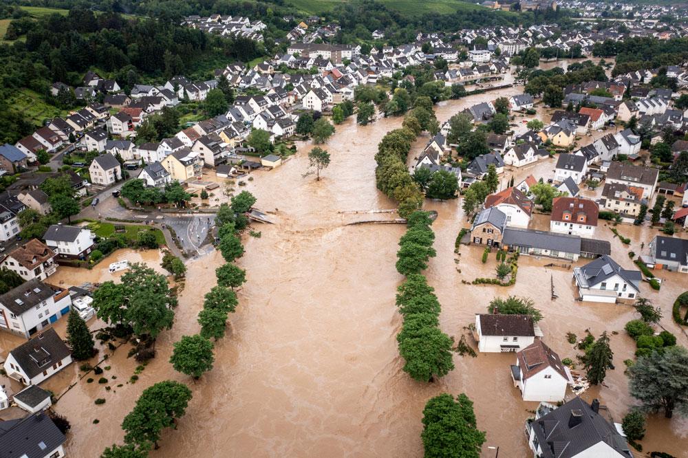
A new AI-powered data model from Snowflake has helped to identify 1.2 million undefended buildings in England at risk of flooding.
The findings come from the Intelligent Flood Readiness Model, created by Snowflake, the AI Data Cloud company, built on Ordnance Survey (OS) data.
The model combines OS’s highly-detailed and frequently-updated buildings data with a range of government data and current Flood Risk Management Plans (FRMPs). Based on model analysis of available datasets, the output suggests that as many as 1.2 million buildings in England are at risk of flooding, but fall outside any current flood defences.
The model layers mapping, flood risk and social deprivation data and estimates that up to 68 per cent of these buildings could be highly vulnerable to the after-effects of flooding – at elevated flood risk, but also located in deprived areas and potentially lacking the resources and social infrastructure to help recover quickly.
As many as 84 per cent of this buildings were built before 2001, when legislation ensured flood risk was factored into planning permissions. The model also suggests that 15 per cent of the at-risk premises date from before 1919, and 23 per cent from 1919 to 1959, so were potentially built before their location became a flood risk.
The model combines six entirely separate, critical data streams and synthesises them into a single, shared "structural intelligence" layer. By cross-referencing OS’s authoritative building datasets with the Indices of Deprivation in England, the analysis was able to identify where physical vulnerability (building height and type) intersects with social risk. This was then layered against Environment Agency (EA) flood data, the EA’s Rivers and Sea defended and undefended flood risk extents, and an AI-driven text analysis of over 3,000 pages of statutory FRMP documents.
It is hoped that the model will help policymakers better understand, over relatively small, detailed areas, not just the likelihood of flooding, but how vulnerable neighbourhoods may be to its effects.
Areas around the east coast of Yorkshire and the Humber have the highest estimated concentration of undefended, vulnerable properties.
Around two thirds (64 per cent) of buildings affected classed as residential, 15 per cent are commercial, 10 per cent industrial and approximately 5 per cent infrastructure.
The model sets out five key recommendations for policymakers to explore in order to better address the growing flood risks facing England. First, it suggests using the ability of advanced models to analyse highly granular data so that policymakers can move away from treating large geographic areas as homogenous and instead account for vulnerabilities at neighbourhood or even individual‑building level. This would not require thousands of bespoke plans; for example, a single protocol for period properties with basements could be applied wherever those property types are identified.
Second, policymakers should identify clusters of vulnerability, particularly where these clusters cut across arbitrary boundaries such as local authority borders or Flood Risk Management Plan zones. Third, the model highlights the need to examine investment in surface‑water infrastructure. Because most at‑risk properties are exposed to surface‑water flooding, targeted spending on often‑unseen assets such as improved drainage could deliver significant benefits.
Fourth, it recommends incorporating vertical risk assessment by considering a building’s height as well as its footprint, and by developing specific emergency protocols for high‑rise structures. Finally, the model advises factoring social deprivation into resilience planning, as levels of deprivation strongly influence how well an area can respond to and recover from flooding. Two places may share similar natural geography and building types but have very different levels of resilience depending on their socioeconomic conditions.
Tim Chilton, Managing Geospatial Consultant, Ordnance Survey said: "Ordnance Survey is excited to collaborate with Snowflake to develop an innovative AI model that could help Local Authorities better understand, plan for, and manage floods. Built on OS’s authoritative and trusted geospatial data and developed using Snowflake’s technology, the model provides insights into how well areas and properties are protected and where to prioritise investment in critical flood defences. By delivering geospatial intelligence difficult to derive manually, decision-makers can access data-driven, actionable insights - without the burden of analysing endless spreadsheets. The model maps vulnerable zones and identifies areas at greatest risk, helping local government shape policy, direct resources, and safeguard communities.”
Fawad Qureshi, Global Field CTO, Snowflake said: “Data is at the heart of making informed decisions. As this project shows, it’s rare that one body holds all the relevant data or that this data is in the same format. But we’re now in an era where technology can bring together the right people and the right data to collaborate on making better informed decisions.”